Iron in the Pre-Contact Arctic
Paddy Colligan, Anthropology
Faculty Advisor: Tom McGovern
NML Award: The New Media Lab Digital Dissertation Award (May 2016)
Pieces of iron have been used in tools in the North American Arctic for many centuries or even as long as the last two millennia. A question that interests Arctic specialists is how the use of iron developed given that there is no naturally-occurring iron (except for meteoric iron) and no tradition of metallurgy to extract iron from ore in the pre-contact Arctic.
Before trade connections were established with the global economy, iron for tools is understood to have come into the Arctic from three sources: from a meteor that crashed in Greenland a couple of thousand years ago; from the traditional intercontinental trade with Siberians and perhaps other people in Asia; and from the Norse colonies in Greenland or early European naval ventures into the Arctic.
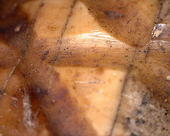
One of the difficulties with finding any evidence of iron at all is that it corrodes; also, since it was never used in large pieces, the small pieces are used up. I am trying to get around the problem of iron’s near invisibility by looking for proxy evidence for iron in addition to any artifacts that have survived. One form of proxy evidence I am looking at is the nature of cutmarks on objects — is it possible to tell if they were made by stone or metal tools? For this I am making photographs of cutmarks using a small, portable microscope that plugs into a USB port on my notebook. You can see some of these micrographic images at the flickr link mentioned below.
The use of iron tools and the cultural, technical and economic mechanisms that facilitated the trade to obtain it will all figure into this project. The data I am collecting for my dissertation at this time will largely consist of photographs and measurements of artifacts stored in museum collections. My work in the New Media Lab will be to adapt existing digital software and techniques to manage, analyze and display them.
Currently there are three components to the data:
 The photographs —
http://www.flickr.com/photos/98675212@N07/sets/
An ever-expanding, indexed collection of micrographic and macrographic photos of tools relating to iron from several museums. Flickr offers several advantages over conventional storage like the laptop hard drive, flash drives and cds that I have used in the past: when I am on the road visiting museums the photos can be uploaded each day minimizing the risk of losing them. Also with all of my photographs up on flickr I always have access to the whole collection to date. I can assign preliminary tags immediately and add controlled vocabulary terms (a set list of terms) later. Since flickr’s tags are fully searchable this will be very useful when my collection is large and I want to pull out illustrations or a selection to analyze in a particular way. (I use a single photo number to link all micro and macro images of the same artifact.)
The maps —
Using GIS software, maps will be created to show the distribution of iron tools, sites, and other data and to explore the interactions that exist between geographic variables.
A spreadsheet of known occurrences of iron that will later be linked to the GIS maps —
This database will enable the researcher to see the extent of known occurrences of iron in the region.
Depending on how quickly this comes together, the research results can be shared through an OMEKA website using OMEKA to incorporate both graphic images and text.