Risky Images of Climate Futures
Sheehan Moore, Anthropology
NML Award: The Social Justice Award (June 2018)
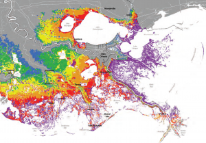
This project examines images that claim representational authority over future landscapes in southern Louisiana. These images include maps and digital renderings of disappeared coastlines, subsiding lands, and underwater Main Streets – topographies that do not yet exist but that nevertheless demand action in the present. They enter circulation in urgent news stories and fifty year urban master plans, and they are magnets for words like ‘resilience’ and ‘retreat.’ At public planning meetings, predictive maps that stage the parish landscape over coming decades are important guides for community decision-making.
In order to better understand these risky images, the futures they purport to represent, and their effects in the present, this project asks after the kinds of data sets and attendant assumptions that go into mapping these not-yet-existent landscapes. What inclusions and omissions make them possible? What contingencies or uncertainties are elided? These questions can help us understand how representations of climate futures set the parameters for action and imagination.
At the same time, this project examines alternative cartographies that tell different stories around the contestation of coastal land. In partnership with environmental and activist groups, it seeks out other data sets, including pipeline routes, new land development permitting, and industry-related habitat destruction. Out of these data, presented alongside histories of environmental racism and Indigenous displacement, the future coast can be understood not just in terms of land loss and sediment diversion but as the site of active struggle. A supplementary component to this work is a pedagogical module that will help students map their own contested environments.